Manston Airport reopening could push ‘Flight Blight’ ratings to ‘Serious’ across East Kent, with up to £319 million in property value at risk
New analysis models the impact of proposed cargo flight paths on Ramsgate, Herne Bay, Birchington and surrounding communities - with potential house price reductions of up to £25,800
New analysis from My Flight Path has modelled the potential impact of Manston Airport’s proposed reopening on residential properties across East Kent and shows that communities under the proposed flight paths could see their ‘Flight Blight’ ratings deteriorate from ‘Minor’ to ‘Serious’ - with aggregate property value at risk of between £266 million and £319 million.
Manston Airport, located on the Isle of Thanet, has been closed since 2014. The developer plans to reopen it as a dedicated air cargo freight hub, handling widebody freighter aircraft including Boeing 747-400F and 777F. The consultation proposes flight paths that would route aircraft over Ramsgate, Herne Bay, Birchington, St Nicholas-at-Wade, and Broadstairs at altitudes as low as 900 feet on approach and 500 feet on departure.
My Flight Path provides detailed ‘Flight Blight Reports’ used by property buyers, estate agents, surveyors and mortgage lenders to assess flight path exposure. Each report analyses millions of aviation data points on aircraft type, altitude, frequency, timing and noise levels over specific properties.
With Manston closed for over a decade, the affected areas currently enjoy minimal levels of aircraft activity. My Flight Path's analysis projects what would happen to Flight Blight Ratings (which rate properties from 0 (worst) to 100 (best) across six bands: Minor, Notable, Moderate, Serious, Severe, and Critical), once Year 10 operations are reached:
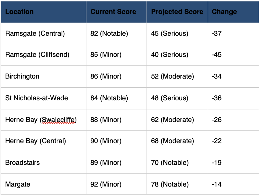
Cliffsend, which sits directly beneath the primary approach path for Runway 28, faces the steepest decline - a 45-point drop that would take it from one of the least impacted categories to one of the worst.
Jono Oates, Co-Founder of My Flight Path, said: “What makes this analysis particularly striking is the sheer scale of change. These communities have had virtually no Manston-related aircraft activity for over a decade. The proposed flight paths would introduce widebody cargo freighters, some of the loudest commercial aircraft in operation, flying at extremely low altitudes over residential areas. The shift from ‘Minor’ to ‘Serious’ is not a marginal change, it’s transformational.”
Why cargo changes the equation
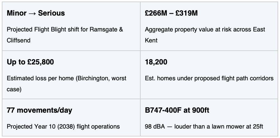
The proposed cargo operations at Manston would involve aircraft that are significantly louder than the passenger jets most people associate with airport noise. A Boeing 747-400F on approach at 900 feet produces approximately 98 dBA at ground level - louder than a lawn mower. For comparison, an Airbus A320 at a similar altitude produces around 88–90 dBA.
Crucially, cargo operations tend to extend into night-time hours. Under the standard Day-Night Average Sound Level (DNL) methodology used by the CAA, flights between 11pm and 7am carry a 10-decibel penalty, reflecting the disproportionate impact of night-time noise on health and wellbeing. Even a modest number of night freight movements can significantly increase the overall noise burden on a community.
The potential cost to homeowners
My Flight Path research has shown that property values decrease by 0.5-0.6% for every decibel of aircraft noise above ambient levels of 40-45 dBA. For homes under busy flight paths, where noise exposure is consistently elevated, that can equate to a significant reduction in property value - tens of thousands of pounds off a typical UK home.
My Flight Path has modelled the potential impact on property values across the affected areas in East Kent:
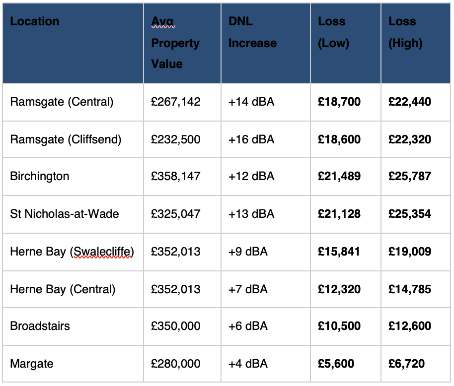
Extrapolated across an estimated 18,200 homes in the affected flight path corridors, the aggregate property value at risk reaches £266 million to £319 million.
Jono Oates, added: “To put it in everyday terms: a 747 freighter at 900 feet produces 98 decibels, louder than a lawn mower running next to your window. The projected noise levels across Ramsgate and Cliffsend would exceed the CAA’s 63 dB threshold at which residential areas are considered significantly affected by aircraft noise. The financial impact on property values is not theoretical, it’s the predictable consequence of routing widebody cargo aircraft over residential neighbourhoods at low altitude.”
A blind spot in property searches
The Manston situation highlights a wider gap in how properties are bought and sold in the UK. Standard property searches and surveys cover structural condition, title, planning, flood risk, and environmental hazards, but aircraft activity remains largely invisible to buyers, even in areas where flight paths can change dramatically due to airport expansion, airspace redesign, or, as in this case, a closed airport reopening. Air traffic is also highly seasonal, nearly 50% more flights operate in August than February in some UK markets and varies significantly by time of day and day of the week. A buyer who views a property on a quiet Monday morning in winter may have no idea what the aviation environment sounds like on a weekday evening in summer.
My Flight Path’s Flight Blight Rating provides a standardised score from 0 to 100 that can be incorporated into property searches, surveys, and valuations, bringing aviation data into the same conversation as school districts, crime statistics, and flood zones.
The company offers house buyers, sellers and residents the opportunity to check their postcode for Flight Blight through a free website tool available here. Future-looking data analysis is also available to purchase from My Flight Path