FAA airspace overhaul to deepen Phoenix’s ‘flight blight crisis’ with up to $1.8 billion in property value at risk
Analysis of 11 Valley zip codes finds 8 face higher noise and falling home values, with just three outer suburbs gaining any reprieve
Phoenix is already one of the most flight-blighted metro areas in America - and the FAA’s proposed airspace overhaul is set to make it worse for most residents. New analysis by aviation property intelligence platform My Flight Path across 11 Valley zip codes finds 8 face higher noise levels and falling home values under the agency’s Performance Based Navigation proposals, putting an estimated $1.07–$1.79 billion in property value at risk. Just three outer suburbs stand to gain any reprieve.
The Federal Aviation Administration’s Phoenix Area Modernization Project - currently in public consultation until June 30, 2026 - will not simply change where flights go. It will determine which of the Valley’s communities bear an even greater noise burden, and which may finally gain a measure of relief.
My Flight Path has analyzed 11 Phoenix-area zip codes, revealing a metro already in crisis. Four zip codes around major airports rate ‘Critical’ - the worst possible band - while the majority of the rest rate ‘Severe’. Not a single Phoenix-area zip code rates better than ‘Serious’ today. The proposed changes will not resolve that. For eight of the eleven zip codes analyzed, they will make it measurably worse.
Jono Oates, Co-Founder, My Flight Path, said “Phoenix is already one of the most flight-blighted metros in America. The FAA's proposed changes don't fix that - they lock it in for most communities, while handing a modest reprieve to a handful of outer suburbs. What the proposals do is decide which communities bear a concentrated, predictable, permanent noise burden and that's a property value decision worth hundreds of millions of dollars, being made right now.
“My Flight Path exists to give the real estate industry and home buyers advance warning of exactly these situations - the financial and health consequences of living under a flight path are real, and too often invisible until it's too late.”
The proposed shift to Performance Based Navigation (PBN) technology, which routes aircraft along precise, satellite-guided corridors rather than dispersing them across a wider area, will concentrate existing flight activity into narrower bands. For communities already under flight paths, that means more consistent, higher-frequency overflights on identical tracks. The FAA’s own Draft Environmental Assessment, published April 2026, acknowledges the project will “change the distribution and concentration of aircraft” and identified “reportable noise increases” in some areas.
Flight Blight Scores: current vs. projected
Flight Blight Scores run from 0-100. Lower scores indicate greater noise exposure - a score approaching 0 represents the most critically affected conditions; 100 represents minimal/zero aviation noise impact.
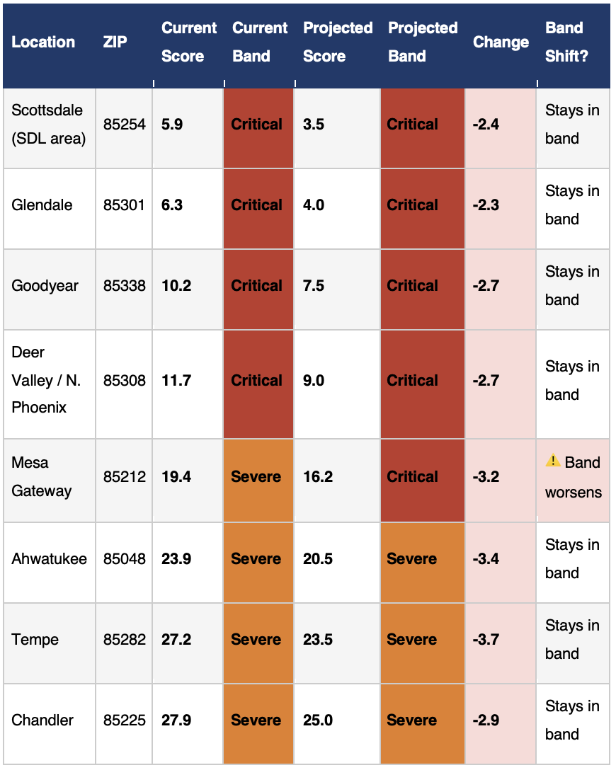
Areas facing increased noise concentration
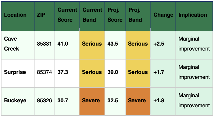
Areas projected to see marginal noise relief
Property value impact
My Flight Path’s analysis applies NBER methodology from the 2025 study “Planes Overhead: How Airplane Noise Impacts Home Values,” which found 0.6-1.0% property value reduction per 1 dB increase in average annual noise levels across three major US airports. PBN's concentration effect of 1.5-4 dB in corridor zones, consistent with post-implementation analyses at Seattle-Tacoma, Boston, and Chicago, translates directly to the property value losses shown below.
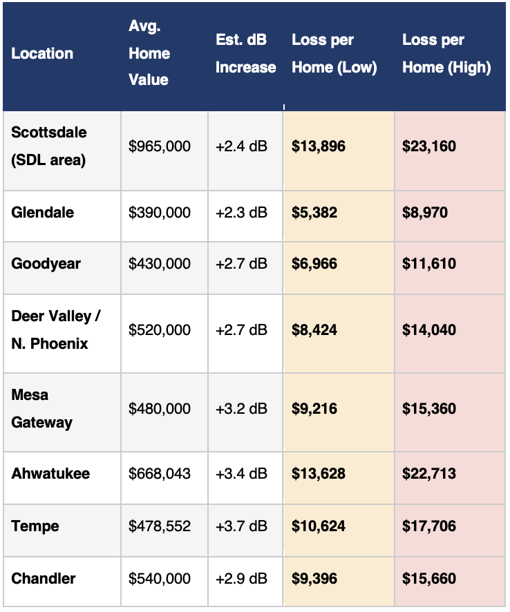
Extrapolated across an estimated 110,000 homes in the direct noise concentration corridors identified by the FAA, using an area-weighted average property value of approximately $560,000 and average PBN concentration effect of 2.9 dB, applied at NBER rates of 0.6-1.0% per dB, My Flight Path estimates the aggregate property value at risk reaches between $1.07 billion and $1.79 billion, with a central estimate approaching $1.4 billion.
A blind spot in property searches
Standard US property searches and disclosures cover structural condition, title, flood zone, and environmental hazards — but aircraft activity remains largely invisible to buyers, even in markets where flight path changes can materially affect property values. The FAA’s own environmental documents are highly technical and do not provide the street-level “before and after” comparisons that homeowners need to assess their own exposure.
My Flight Path’s Flight Blight Score provides a standardised 0–100 rating that can be run against any US zip code, enabling homebuyers, sellers, and real estate professionals to incorporate aviation noise into property decisions alongside school districts, flood risk, and crime statistics. Homeowners in the Phoenix area with concerns about the proposed FAA changes can check their zip code at myflightpath.com.